|
LIFE05 TCY/ROS/000143 |
|
||||

|
|
|
|
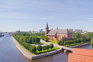
Kaliningrad Region
|
||
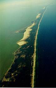
The two spits - Curonean and Vislynskaya (its Russian part is called Baltic) separate two bays from the sea - Curonean and Kaliningrad (the Polish call it Vislynsky Bay). The Kaliningrad region is the only area of Russia separated from the mainland by the territories of other independent states. Its territory is small, about 15.1 thousand km2. It makes only 0,09% of the total area of the Russian Federation and holds 81st position in the country. It is 110 km from north to south, and is 195 km from west to east. The border of the region which is the frontier of the Russian Federation is 540 km long. Nature and resources of the most western region of the Russian Federation are rather diverse, though their scale is not so great due to the dimensions of territory. Practically entire territory of the Kaliningrad region is a low plain with some areas lying below sea level. Only a few hills of the Vyshtinetz upland in the south-east are higher than 200 m (up to 242 m) above sea level. There are polder areas close to the bays. 79% of all the grounds are over wet. Due to this fact and to the flat landscape there are plenty of lakes and the rivers, many of them of an artificial origin. There are about 4600 rivers and reclamation canals and about 4000 ponds and lakes in the Kaliningrad region. The biggest rivers Neman and Pregol are connected by canals into the integrated water system. But the largest internal basins are bays. |
||
|
||
More than 1 million people live on the territory of the Kaliningrad region, only 23% of them are agricultural population. Population density is 62.5 persons per km2, it is almost 5 times more than in Primorye. National structure of the population is various and remains rather stable for a long time: share of the Russian population is about 78%, there are about 8% of Byelorussians and over 7% of the Ukrainians. The rest 7% are Lithuanians (2%), Armenians, Germans, Poles, Tatars, etc. less than 1% of each. The population of region was formed due to the organized, historically conditioned relocation which began in 1945. Almost half a million migrants arrived to the region by the middle of 1950s, and then before the beginning of 1990s the population augmented due to natural increase. The region consists of 13 administrative districts, 3 city districts and 3 towns with the status of separate formations. Cities and districts with high population density are the city of Kaliningrad (1916.8 persons per km2), town of Pionersky (1537.5 persons per km2) and the town of Sovetsk (1077.5 persons per km2). In other areas population density varies from 16 up to 58 persons per km2. The largest towns are Kaliningrad (425.6 thousand), Sovetsk (44.0 thousand), Chernyakhovsk (43.0 thousand), Baltiysk (31.2 thousand) and Gusev (28.1 thousand). The majority of towns and streets have new names in honour of the soldiers heroically battled on the territory of Prussia in the Second World War. The share of the urban population in the Kaliningrad region was always larger than the share of the rural one. But in 1990s due to the increased quantity of migrants - refugees and the constrained immigrants most of whom settled in the countryside - the number of the rural population began to grow faster than of the urban. In conformity with world and Russian tendencies the natural increase of the population is reducing. Specific quantity of children in the total of the population has reduced from 23.4 to 20.2%. The amount of economically active population in the region increased in the recent years and had reached 460 thousand in 1998. But the number of people employed in various sectors of economy reduced from 435 to 386 thousand in the period 1990 - 1995. The amount of unemployed grows and employment reduces. The basic share of unemployed is women. In 1992 they made 80 % of the general number of unemployed, in 1995 - 65%. The youth suffers from unemployment most. Each third unemployed is16 - 29 years old. The power complex of the Kaliningrad region is completely based on imported fuel (heat power plant-2 in Kaliningrad, a state district electric power plant-2 in Svetly). Delivery of coal and fuel oil is complex and expensive: transport charges are comparable with the cost of fuel. In hydro-power engineering the use the Lava River and reconstruction and construction of 9 hydroelectric power stations with the capacity 135 up to 500 kW on the river Pissa are most perspective. There are wind-driven installations 600 kW capacities each at the Baltic Sea coast. One of the most perspective branches of economy in the Kaliningrad region is its transport complex. However in the 1990s shipments by all types of transport reduced. The exception here was air transport that reduced conveyance of passengers only, but increased cargo shipments. The airport in Khrabrovo made flights both international and domestic. There are no local flights about the region. Intraregional railways carry most of the cargoes. The main amount of cargo transportations is between the Kaliningrad region and Lithuania and Russia. They follow along the way that is only 30-40 % busy. The northern line Kaliningrad-Riga isn't practically busy with transportation of cargoes. This is also true for the southern lines to Poland. There is a rather dense network of motor roads on the territory of the region but there is only one 4-line highway 200 km long. The considerable part of shipping by motor transport inside of region and abroad is carried out by the small and individual enterprises. The cargo turnover by all the above named types of transport is dependent on development of water, and especially sea transport in many aspects. |
|